|
GRAND CANYON Explorer
| home
|
|
How To Get There
|

The Grand Canyon is located in northern Arizona about 70 miles north of Flagstaff.
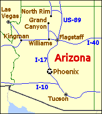
To get to the south rim of Grand Canyon National Park you have a number of choices:
- From Los Angeles and other locations in southern California you should first take Interstate 15 north to Barstow and then take Interstate 40 east from there to Williams, Arizona. From Williams you should take Arizona route 64 north to the Grand Canyon.
- From Las Vegas you should take U.S. route 93 southeast towards Hoover Dam and Kingman, Arizona. From Kingman take Interstate 40 east to Williams, Arizona and from Williams take Arizona route 64 north to the Grand Canyon.
- From Albuquerque and other eastern locations you should take Interstate 40 west to Flagstaff, Arizona and then refer to the directions from there.
- From Phoenix take Interstate 17 north to Flagstaff, Arizona and then refer to the direction from there.
- From Flagstaff, Arizona there are two possible choices for getting to the Canyon:
- U.S. route 180 north to Arizona route 64 north to Grand Canyon (south entrance)
- U.S. route 89 north to Arizona route 64 west to Desert View (east entrance)
To get to the north rim of Grand Canyon National Park your choices are more limited.
- You must first get to Jacob Lake which is about 30 miles north of the north rim park boundary.
- If you are coming from Los Angeles or Las Vegas take Interstate 15 north to its junction Utah's state route 9, which is just north of St. George, Utah. Take UT-9 east, through Zion National Park, to its junction with U.S. route 89 at Mount Carmel Junction. Take US-89 south to Kanab Utah where an alternate route to US-89 splits off. Take alternate US-89 south from Kanab to Jacob Lake Arizona.
- If you are coming from Salt Lake City take Interstate 15 south to it's junction with Utah route 9 and follow the directions given above.
- If you are coming from the east or south (Albuquerque or Phoenix) you must first make your way to Flagstaff. From there take US-89 north to where alternate US-89 (US-89A) splits off, which is just south of Page, Arizona. Take alternate US-89 west to Jacob Lake.
- From Jacob Lake drive south approximately 30 miles on Arizona route 67 to the park boundary.
- From the park boundary it's another 10 miles or so to the north rim.
Driving distances to Grand Canyon National Park (south rim)
| From |
Miles |
Km |
| Albuquerque, New Mexico | 415 | 664 |
| Barstow, California | 387 | 619 |
| Denver, Colorado | 879 | 1,406 |
| Flagstaff, Arizona | 89 | 142 |
| Gallup, New Mexico | 280 | 448 |
| Hoover Dam, Nevada/Arizona | 242 | 387 |
| Kingman, Arizona | 171 | 273 |
| Las Vegas, Nevada | 273 | 436 |
| Los Angeles, California | 507 | 811 |
| Phoenix, Arizona | 247 | 395 |
| Prescott, Arizona | 128 | 204 |
| Salt Lake City, Utah | 594 | 950 |
| Sante Fe, New Mexico | 477 | 763 |
| Williams, Arizona | 60 | 96 |
Copyright © 2001, www.kaibab.org, all rights reserved.