|
Grand Canyon USGS maps - How'd He Do That |
|---|
I determined that creating individual quad maps or even trail maps from the USGS quads was not feasible, due to slight sizing and alignment problems that I encountered when trying to piece individual scans back together. The resulting image files were al so very large and transferring them over the net would suck up a considerable amount of server bandwidth which I was trying to avoid. To get around this problem I decided to break up each quad into smaller, more manageble pieces, which would then be able to be transferred over the net in an acceptable amount of time. By linking each map segment to all of the other adjoining segments via HTML tags the person viewing the map would be able to wander all over the Canyon, from segment to segment and from qua d to quad.
I decided that breaking up each map into 30 smaller segments (5 across and 6 down) seemed to provide about the best resolution for most viewing modes and each map segment would then also be less than 100K. I then labelled the grid so that I could uniquel y reference individial segments of the quads.
| A A | B A | C A | D A | E A |
| A B | B B | C B | D B | E B |
| A C | B C | C C | D C | E C |
| A D | B D | C D | D D | E D |
| A E | B E | C E | D E | E E |
| A F | B F | C F | D F | E F |
The next step was setting up some databases (in Microsoft FoxPro) to contain information about the USGS quads, where they were located in relation to each other, what trails were on them and which ones would have photo indexes. Using these databas es I then wrote a FoxPro program to generate all of the HTML scripts for all of the map segments which would then have links to adjoinging map segments, trail descriptions and photo indexes.
I then needed a process that would allow me to extract the individual segments from each quad so that they would all be of uniform size and would all overlap each other in the same manner. I first thought that I would be able to do this by hand using a g raphics editor but it proved to be too time consuming and so I decided to write another program to automate this task. For this I used Microsoft Visual Basic (version 3.0) because of its ability to manipulate bitmap images.
I determined that it would require six scans of each USGS map to get the whole map into the system. The first scan would yield 6 segments from the upper right corner (DA thru EC), the next would give the 6 segments from the upper middle portion (BA thru CC) and then another would get the remaining 3 segments from the upper left (AA thru AC). This process would be repeated for the lower half of the map (AD thru EF). I setup the program so that I could identify which map portion I was dealing with and bas ed on settings that I could adjust for segment height and width and amount of overlap, I soon had a program that could extract the individual quad segments.
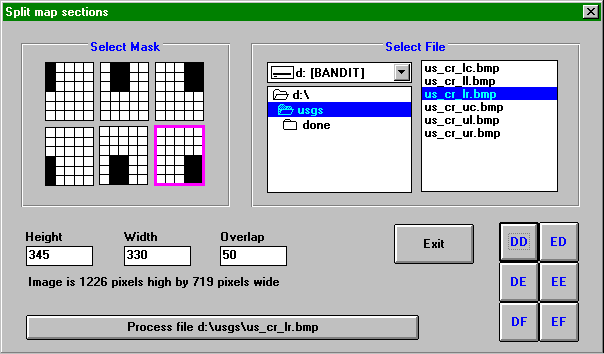
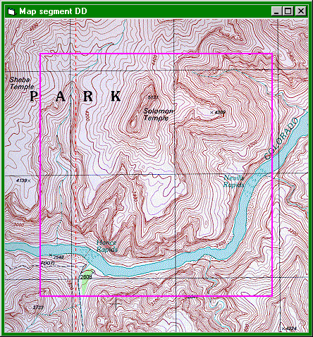
Clicking on the segment buttons in the lower right of the form allowed me to pop-up a window to view the individual map segments. This viewing window would also position a box over the map to outline the actual map segment so that I could see where the o velap was and it would also draw lines showing where scans from adjoining scans would overlap.
Pressing "Process file.." button on the screen caused the entire scan to be processed and the resulting bitmap segments to be extracted and written to disk as separate files.
|
|
|---|
|
|---|